Winds over 100km an hour, thunderstorms forecast for Auckland

RNZ
28 May 2024, 8:48 AM
 Prepare ahead of time by securing any loose objects that could be lifted or moved by the wind. Photo: MetService screenshot
An orange strong wind warning that may deliver 120km/h winds to parts of Auckland has been issued this evening.
MetService says severe gale southwesterlies gusting 120km/h in exposed places may start around 3pm on Wednesday and last around 11 hours.
The gusts "could damage trees, powerlines and unsecured structures. Driving may be hazardous, especially for high-sided vehicles and motorcycles", it says.
It has also placed the region on a severe thunderstorm watch, saying while squally showers were expected there was also a moderate risk of severe thunderstorms.
A strong wind watch is also now in place for Northland from Dargaville and Whangārei southwards.
Meanwhile, power cuts and damage are possible for the upper and western North Island from this evening, NIWA has warned.
Earlier in the day, MetService issued strong weather warnings saying Auckland, Coromandel Peninsula, Taranaki, and coastal Waikato will be worst affected.
Heavy winds, rain and possible thunderstorms are forecast for several parts of the country into Wednesday.
And a NIWA spokesperson also said winds of more than 100km/h were expected.
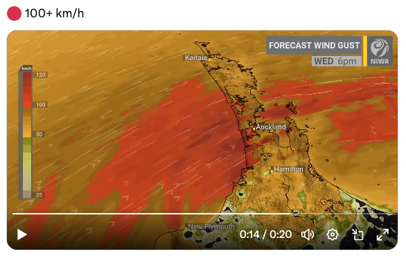
"The strongest gusts are likely over coastal & elevated areas," a post on X said.
"Localised power cuts and damage are possible."
Drivers using the Auckland Harbour Bridge tomorrow have also been asked to take extra care.
NZ Transport Agency Waka Kotahi said it was likely speed limits would be reduced and some lanes could be closed if winds reached threshold levels.
With the strongest gusts forecast for midday and again from 6-7pm it was possible the bridge could be shut down completely temporarily, the trasnport agency said.
Drivers of high sided vehicles and motorcyclists were advised to avoid the bridge and use the western ring route on State Highways 16 and 18.
MetService has issued a long list of warnings or watches affecting Auckland and a part of Waikato in the north and extending as far south as Stewart Island.
Souwesters may hit gale levels in exposed places in parts of Auckland, including Great Barrier Island, from 4pm tomorrow.
People were being advised to secure outdoor items such as wheelie bins and trampolines.
The strong wind watch also takes in the west coast of Waikato north of Kawhia Harbour, the Coromandel Peninsula and the Kaimai Range.
Western Taranaki from Urenui to Hawera may also be in for a similar dose of strong winds from 2pm tomorrow.
Heavy rain is forecast to move up the west coast of both islands also and reach Auckland and Northland later in the day.


