Tropical Cyclone Gabrielle heading our way

Metservice
08 February 2023, 4:55 AM
 Covering period of Wednesday 8 - Sunday 12 February.
The tropical low in the Coral Sea that MetService has been monitoring over the last few days has intensified into a tropical cyclone, named Tropical Cyclone Gabrielle by Australia’s Bureau of Meteorology this afternoon.
At 1pm Wednesday afternoon New Zealand time Tropical Cyclone Gabrielle was located more than 700km northeast of the coast of Queensland.
It is expected to track southwest remaining over water, before re-curving towards the southeast on Thursday, putting it on a likely path towards New Zealand.
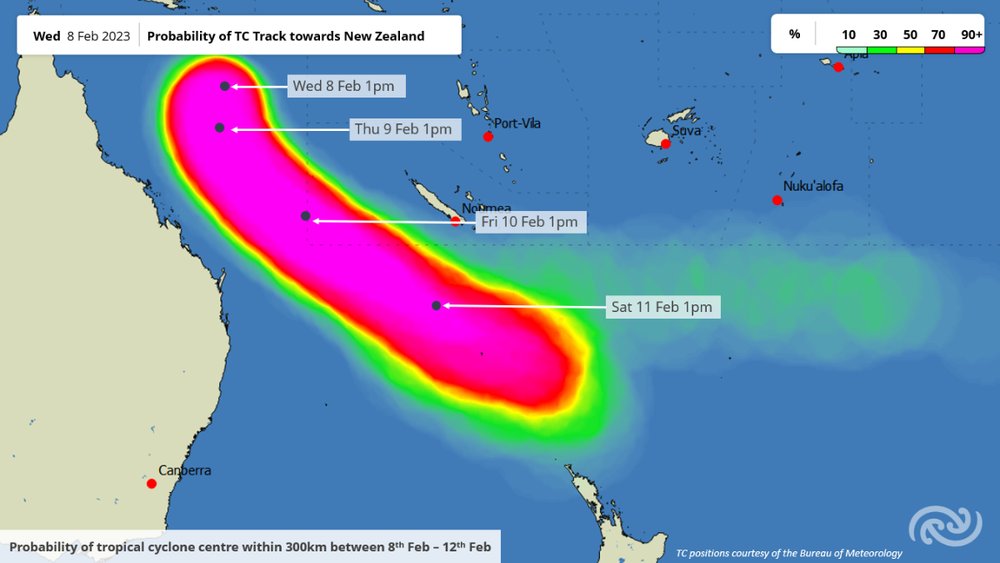
It will continue on this track until it comes close to Northland late on Sunday.
“Although by the time it draws close to the top of the North Island it will have lost its tropical characteristics, it is still expected to be an intense weather system,“ says MetService meteorologist Mmathapelo Makgabutlane.
“Likely impacts of this system include heavy rain, gale force winds and large waves leading to dangerous coastal conditions for the upper North Island into early next week.”
There remains uncertainty around the exact path of Tropical Cyclone Gabrielle as it approaches Aotearoa New Zealand, and how things play out will be determined by what happens in the coming days.
“A slight change in atmospheric conditions may influence the track and speed of Tropical Cyclone Gabrielle, which will affect the intensity and location of expected impacts,” adds Makgabutlane, “This could affect some of the areas which have already seen significant impacts from recent weather events.”
People are advised to continue to stay updated with the latest MetService forecast.


